Hex Crawls
- Thread starter squeen
- Start date
Pseudoephedrine
Should be playing D&D instead
For coordinates, I use letters going along the short axis, and two numbers along the long axis of the map. A00 is the top left of my landscape oriented maps. I just repeat this across maps and then number the maps with Roman numerals, so "I C18" can be read pretty easily to figure out where things are. It seems fairly straightforward to key things that way.
Beoric
8, 8, I forget what is for
I wish you could do this in Worldographer.For coordinates, I use letters going along the short axis, and two numbers along the long axis of the map. A00 is the top left of my landscape oriented maps. I just repeat this across maps and then number the maps with Roman numerals, so "I C18" can be read pretty easily to figure out where things are. It seems fairly straightforward to key things that way.
robertsconley
Should be playing D&D instead
Nothing wrong with being a fan of the Wilderlands. The father was a decent person. The son however has issues along with some of the grandsons.Look at the Wilderlands for the platonic example. The original is great of course, but the Necromancer Games version is incredibly detailed. Rob Conley, who posts here sometimes, did a ton of work on it. It's fucking expensive and hard to get physical copies nowadays, though. I am a huge fan of the setting so I dropped some dough on eBay but since Judges' Guild is persona non grata everywhere now, well... I won't advise you further.
The whole reason for both Points of Light and later Blackmarsh to make all that more approachable and affordable.Points of Light from Goodman Games, also by our man Rob Conley - this is cheap to get in PDF and has four small settings with hexmaps. Definitely worth your time.
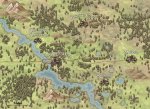
The next iteration I working on is designed around DriveThruRPG 12" by 18" poster map. The first one will combine Blackmarsh, Southland, the Wild North and new material into a four map set. Then I will make additional installments. The below is my working copy of the four maps combined.
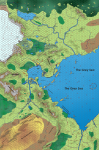
It is part of a much larger map that I will crop other releases out of. The reason it looks great is because of the hundreds of 5 mile hexes in the master map.
robertsconley
Should be playing D&D instead
Glad you are enjoying them.CRAWLING ROB
HAIL THE HEX
On Robs rec I just printed matte poster maps of his recent wilderlands map redo and the city state
....
Beautiful work
robertsconley
Should be playing D&D instead
It wasn't pleasant to deal with. As I stated in my post, I talked to Bob II first, and afterwards the other licensees second. At the end of the day I wasn't going to do business with either Bledsaws. Also I knew my sudden absence would be noticed in the hobby and industry so prepared a post. After I talked to the licensees, it quickly became public and so I posted what happened. It didn't surprise me that it became public after talking to the other licensees as from what I knew personally they would not react well to somebody spreading anti-Semitism material. Then Bob II wrote a long post and that as they say was definitely that.Yeah I went and looked it up yesterday.
I still track the royalties and at the current rate of sales it looks like what the Bledsaws owe me will be settled by late 2022 early 2023. By then I will have my original stuff based off Points of Light/Blackmarsh posted. Not what I wanted after having been able to work with the Wilderlands direct but since things haven't changed with the Bledsaws it what it has to be I guess.
The silver lining is that I laid the ground work over a decade by noting what in the Majestic Wilderlands was original to me and what was Judges Guild stuff. I wasn't expecting a license back then to use the material so prepared accordingly.
Melan
*eyeroll*
Our GM in an ongoing online Helvéczia campaign uses it a lot. It is apparently an excellent mapper, and the results certainly look nice (especially with that painted icon set). Do note, however, that the EULA only allows you to use the icons bundled with the app on a strictly non-commercial basis.Anyone tried Hex.Kit on Itch io
I really like it

I really like using it to create the hex map and key on it directly. That way I can run the game through the program by mousing over, it works well as a DM tool and you are right it makes pretty things, the UI seems more intuitive than worldogropher IMO.Our GM in an ongoing online Helvéczia campaign uses it a lot. It is apparently an excellent mapper, and the results certainly look nice (especially with that painted icon set). Do note, however, that the EULA only allows you to use the icons bundled with the app on a strictly non-commercial basis.
That sucks, I wonder what are the best tile sets that use creative commons or let you sell your work
TerribleSorcery
Should be playing D&D instead
I love Hex Kit as well, very easy to use and the tilesets look great. Somebody put out a tileset for use in published products on Drivethru, I don't remember the name though...
Pseudoephedrine
Should be playing D&D instead
Yeah same, and Worldographer maps are the main exception to me following this practice.I wish you could do this in Worldographer.
Beoric
8, 8, I forget what is for
Yeah so does Worldographer, but I can't remember if it is available with the free version.Inkarnate has a hex overlay, for whatever that's worth.
The thing that does keep me coming back to Worldographer (and the reason I bought the paid version) is the "map levels" function, which lets you zoom in on a hex to make a more detailed group of subhexes. So you make your world with say 24-30 mile hexes, and then you tell the program to make a "continent level" map, and it populates all the large hexes with, say, 5-6 mile hexes - randomly generated but consisting with the top level hex. And then you can make another "kingdom level" map with, say, 1 mile hexes. And there is a beta version that makes "province level" hexes if you want to zoom in even more.
I would probably give HexKit a try, but I have SO much invested in my Worldographer maps that would have to be re-done...
The1True
8, 8, I forget what is for
Yeah man, someone here encouraged me to get in on that Campaign Cartographer Humble Bundle which I bought, installed and promptly forgot. Worldographer was easy to figure out and just got in first. Probably the same reason my group is stuck on Roll20 even though there are some increasingly more appealing options out there...I would probably give HexKit a try
TNAVELER

 matt-landofnod.blogspot.com
The Evolution of Method
Today I'm going to chime in with a couple helpful tips for those out there writing their own hex crawls. I've written more than a few of the...
matt-landofnod.blogspot.com
Beoric
8, 8, I forget what is for
I like Campaign Cartographer, but I just don't have time to make those kinds of maps any more.Yeah man, someone here encouraged me to get in on that Campaign Cartographer Humble Bundle which I bought, installed and promptly forgot. Worldographer was easy to figure out and just got in first. Probably the same reason my group is stuck on Roll20 even though there are some increasingly more appealing options out there...
squeen
8, 8, I forget what is for
Your a nut!HANKTay OUYay ORFay OURYay IKELay QUEENSay
")
Magestic Stars sounds great @robertsconley !
Would this be a Cepheus Engine hack? I am reading the Traveller Book per Grognardia and the mix of hard sci fi and DM Fiat reminds me of ODnD
I don't have a metric for this but it justifys as non DnD system in a way few RPGs do? I can see myself liking it! More than DnD BX in space like Stars Without Number ( ideal generation and DM tools withstanding)
TerribleSorcery
Should be playing D&D instead
This is the one. Hex Kit tilesets allowed for commercial use. Looks cool, but I haven't tried it:
 www.drivethrurpg.com
DriveThruRPG
www.drivethrurpg.com