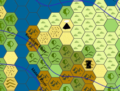
On Hexploration, a closer look
It's been out for a while, I figured I'd talk about what's inside. This is an screen resolution example of a hex from the Hexplore serie...
 hackslashmaster.blogspot.com
Hex Mapping and Resources
I have begun creating a hex map of Alnwich and the surrounding land. I am largely following the advice of The Welsh Piper and The Alexandr...
 abovetheflatline.blogspot.com

Into the Wild... erlands
This is the system I'm using for hex crawling in the Wilderlands. It is primarily based on this Unearthed Arcana article , but it also d...
 inplacesdeep.blogspot.com

[Review] Times That Fry Men's Souls
Times That Fry Men's Souls is a campaign setting written by Seann McAnally / Nerd Glows On . The weird historical setting lends it to...
 eldritchfields.blogspot.com

Wilderness rules, a wishlist
I'm looking for a good set of wilderness travel rules. The setting of Signs in the Wilderness is a wide, poorly-explored country, where se...
 signsinthewilderness.blogspot.com
Hexcrawling In Fassulia And Beyond
So I'm playtesting Lungfungus's Fassulia and it's going well so far, but I'd like to talk about some things I do with hexcrawls (or rather ...
 wizzzargh.blogspot.com

North-West Marches - Travel Rules
Credit Eric J Fitch Hex generation For each newly viewed hex, roll on the following table twice and combine the results. If y...
 meanderingbanter.blogspot.com

The Bone Marshes: A Hex-Mapping Adventure About Getting Lost
A tabletop RPG adventure packed with mapping and navigation challenges.

Approximating the area of a hexagon
I needed to figure out how many square miles are in a hexagon. Turns out, nobody wants to give a straight answer when all you know about the hexagon is the distance face-to-face, which is what we a…
 1d30.wordpress.com
Hexcrawl
As part of my essay on game structures in roleplaying games, I specifically discussed the basic structure of the hexcrawl:(1) Draw a hexmap. In general, the terrain of each hex is given as a v
 thealexandrian.net
A Set of Unified Wilderness Travel Procedures
OSR RPG blog with a focus on mechanically reinforcing immersion and thematic elements of story.
 melancholiesandmirth.blogspot.com

Almost-Encounters: Sights, Sounds and Leavings
Regularly, when I roll for random encounters underground or outdoors in a game, I allow for the possibility that some kind of clue to an enc...
 rolesrules.blogspot.com

A Marked-Up Map
I'm much too kind to show the influence map the Band of Iron left behind in the northern lands. Let's just say that purple worm example in...
rolesrules.blogspot.com
Old School Fantasy Hexcrawl Resources
Ever since Troy's article about running red box D&D for his kids at the end of January, I've been immersing myself in the OSR (Old School Renaissance). It's been a ton of fun, and one aspect in particular has been some of the most fun I've had as a GM in years. Even though I started gaming with...
 gnomestew.com

[BLOG] Shallow and deep wilderness sandboxes
Difficulties concerning this area of play notwithstanding , most of us manage to create and run rewarding wilderness adventures. The OD&D...
 beyondfomalhaut.blogspot.com

Travel Times for Old-School Hex-Crawling
Here’s the handy-dandy chart I’m using to calculate travel times for “province-level” hex-crawls in my Panzoasia Campaign. It’s keyed for a scale of “1 Hex = 1 League”, which I prefer because it co…
 engineoforacles.wordpress.com

Travel through the Wilderness, references
Looking for sources to run a wilderness game? Here are some great blog posts I've been reading lately (some from better authors than m...
signsinthewilderness.blogspot.com
Rules for hex crawls? | Dungeons & Dragons / Fantasy D20 Spotlight
What are your favourite sources for hex crawl rules and mechanics? Heck, what are your favourite rules and mechanics for hex crawls? The last time I interacted with the idea was the 5e adventure path that took place in the jungle continent, had a ruined city full of animal-themed temples, and a...

[BLOG] Let me use Huberic of Haghill
Accidental genius or random content mill? Opinions vary about Judges Guild, but there is a truth to both descriptions. Here was a pioneer ...
 beyondfomalhaut.blogspot.com
Reactions to OD&D – Hex-Clearing Procedures
Not to be confused with hexcrawling, hex-clearing is the process by which monsters and other hostile forces were cleared out of a hex in preparation for a stronghold to be constructed. Clearing a he
 thealexandrian.net
[BLOG] Shallow and deep wilderness sandboxes
Difficulties concerning this area of play notwithstanding , most of us manage to create and run rewarding wilderness adventures. The OD&D...
beyondfomalhaut.blogspot.com
Travel and hex-crawling, part two
Read part one here : https://daimon-games.blogspot.com/2019/10/travel-and-hex-crawling-part-one.html In this new post, we start by looki...
 daimon-games.blogspot.com

In the Heart of the Unknown | Procedural Hex Crawling Engine
In the Heart of the Unknown – A Procedural Hex Crawling Engine ‘In the Heart of the Unknown’ contains procedural Encounter, Terrain and Weather Engines for Wilderness Hex Crawling…
goblinshenchman.wordpress.com
Hex Flower Game Engines | an overview and some thoughts
Background: For about the past year I’ve been blogging on-and-off about Hex Flower Game Engines (they are like a random table but with a memory). For example here and here. Download I decided…
goblinshenchman.wordpress.com
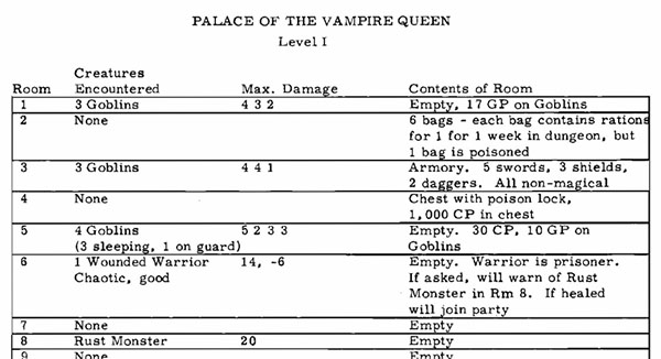
Hexcrawl Addendum – Sketchy Hexcrawls
As described in The Art of the Key, the first published module for D&D was Palace of the Vampire Queen. It used a very simplistic, tabular key:A year later, Judges Guild would release Wilderla
thealexandrian.net
Best hex template? | Original D&D Discussion
What templates do you use in your hexcrawls? For me, the numbered grid is a must. Some space left to make notes is also welcome. Few examples: http://quicklyquietlycarefully.blogspot.com
 odd74.proboards.com
Last edited: