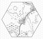
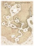
Totally readable, but I have to go with Heritic's assessment --- it's too symmetrical.
To be honest, it's not my cup of tea for a few other reasons:
- the colors are too "loud" (for me) even though they do harken back to the Greyhawk map
- I am blown away with your GIMP brush skill, but my eye generally does not like icons that fit neatly into hexes. I know that many people do, but I prefer a (irregular) map image of forest, mountains, etc., with a hex lightly laid over top.
- There's nothing that screams "explore!" because of its strangeness, weird topology, or inexcessibility
I'm probably asking too much of a map. Wish Bryce would chime in. He's seen more than all of us.
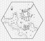
I don't mind the symmetry. Nature is often just off symmetrical, and that does that. Also, this is an "escape" scenario, not a "clear" scenario, so the player's will likely never see the whole map. A little symmetry will allow them to make guesses about the landscape which they may need to survive.
For the same reason I don't think there needs to be terrain features that scream "explore", although there may need to be features tat scream "hide".
I like strong colours so that terrain changes are immediately apparent. I don't like the Greyhawk colours for hills or mountains. That brown always makes Greyhawk hills look like badlands, or the really rocky, arid hills you see in Westerns. It is so strong I can't get it out of my head even if I know the hills are supposed to be grassy downs or heather-covered moors. And mountains always look gray, or gray-blue to me, except near the equator where they are covered in forest.
I feel like the colour-icon combination isn't used to good enough effect, not just in this map but in pretty much every hex map I have ever seen. Like, there is no valley symbol for highlands, but what if you used your "hill" or "mountain" colour with your "grassland" icon? Or used the occasional "hill" icon in grasslands along with the "grassland" colour to indicate this is a low grassy hill and not a change in the overall terrain? Or a lone patch of trees in the plains using the "tree" icon with the "grassland" colour? Then your grassland gets interesting terrain features without losing its "grassland" quality, and there may be obvious places for the PCs to try to hide.
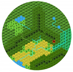
I also feel like there needs to be a hexmap notation to show the natural flow through terrain. Unlike hexes, where travel in any direction is apparently equally easy or difficult as long as there is no change in terrain type, IRL one direction may be easier than another. One side of a hill may be steeper than another, or there may be a creek, or patch of bog or scrub or trees, or a small ridge, that makes it harder to travel in one or more directions. Hexmaps are too large a scale to convey changes in microterrain (zoom in to a 1 mile or 6 mile sections of the Rocky mountains in Google maps and you will see what I mean), but it would be nice if there was a way to hint at it, or naturally channel PCs in a given direction.
I have considered coloured lines on hex borders to show natural barriers between hexes, but that again implies you need to have strong colour differences to indicate terrain types. It would be a lot of work to do each hex on a whole map, so maybe a notation that the DM can add when running a crawl, combined with a set of tables to determine how many "exits" there are likely to be in a hex of a given terrain type, and what the barriers would be?
")