Feedback Thread: Maps

The1True

8, 8, I forget what is for
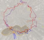
The turquoise are wooden walkways. Pink is ladders. Yellow is ropes and ziplines. I had to colour the lines to more easily select them in PS. It's an entirely mechanical decision as opposed to a design one. The above quick mockup has absolutely no height data. If it would help, I could try to colour code the heights so we can see what's beneath what... I'll see if I can find a moment while I'm rendering a scene later (Squeen'll know what I'm saying. It's like the artist version of 'compiling') ;)
 

Beoric

8, 8, I forget what is for
Ok, so the blue to purple is like one level, and the red to yellow is like another level. So you could conceivably have them on separate maps. But each level is actually pretty simple. With all the bends I'm also thinking that would be a PTA to move tokens around on a VTT, and setting up the vision blocking layer is going to be a challenge. Might you be better with a true flowchart, and battlemaps for key sections?

Hmm, it would be pretty cool if you were using a VTT and set up each "level" as a transparency, so you could overlay as many as you needed at the time. So keep it to one layer if they aren't thinking of changing levels, but overlay another if they get to stairs or a rope or something. But for most users, a flowchart might be better.
 

The1True

8, 8, I forget what is for
Hmm, it would be pretty cool if you were using a VTT and set up each "level" as a transparency
I see what you're saying. Especially since many of the platforms can see each other, so it would be cool to keep track of all the moving pieces while climbing. I'd have to carefully label some of those multi-level ladders though. It's hard to tell where they begin/end. Also, it might turn to a busy mush of linework when I add a grid. I think everything's a little to tangled to be considered discrete levels.

I had envisioned the ropes/rails etc. as part of the dynamic environment. i.e. that combat could break out while PC's are still negotiating difficult transits between platforms. But, I think a flowchart connecting platform battle maps is a good idea. Something to include in an appendix or map pack.

I tried to render a 3/4 orthogonal shot of the tree (without the trunk in the way) but so far I'm not having a lot of luck getting a clear view of all the platforms.
 

Beoric

8, 8, I forget what is for
I see what you're saying. Especially since many of the platforms can see each other, so it would be cool to keep track of all the moving pieces while climbing. I'd have to carefully label some of those multi-level ladders though. It's hard to tell where they begin/end. Also, it might turn to a busy mush of linework when I add a grid. I think everything's a little to tangled to be considered discrete levels.

I had envisioned the ropes/rails etc. as part of the dynamic environment. i.e. that combat could break out while PC's are still negotiating difficult transits between platforms. But, I think a flowchart connecting platform battle maps is a good idea. Something to include in an appendix or map pack.

I tried to render a 3/4 orthogonal shot of the tree (without the trunk in the way) but so far I'm not having a lot of luck getting a clear view of all the platforms.
For the dynamic combat aspect you may be better off with battlemaps of the platforms and other unusual features, and a couple of generic "walkway" maps for random encounters, a la D1-2.
 

The1True

8, 8, I forget what is for
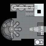
So I've been up to my eyeballs for months dithering away at this moving 'megadungeon' thing. I'm getting down to the nitty gritty of clarifying imagery so it's understandable to the DM, gating and finally numbering the rooms. I've been hitting a lot of interesting issues with giant three dimensional rooms. Rooms so large, they have smaller buildings and chunks of dungeon running through them. I'm wondering how best to present these environments in a map pack. Currently, what we're looking at is a 2D, top-down, orthogonal presentation like this:

CraneRoom03.jpg

blue lines are windows. hyphenated lines indicate overhanging structures. blank space is open space (the area outside the room would present as black, but I left that out of this mockup).

as a side note, almost all of these stairs travel up and down. I'm trying to think of a way to show that without cluttering the map.

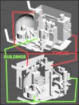
anyway, all of this maps an area that looks like this:
CraneRoom02.jpg

obviously, my predilection for videogame level design is bleeding in here. If I were trying to express this environment to the players, particularly if there was to be a big mini-boss battle in the wider room area, should I include the above as a visual aid or should I be attempting a 3/4-view battle map? Should I avoid spaces this large altogether?
 

squeen

8, 8, I forget what is for
Looks cool.

My knee-jerk reaction would be to have your top-down view with opaque interior buildings, and them isolated inset maps of those builds (stand alone), like one might do with a town.
 

The1True

8, 8, I forget what is for
My knee-jerk reaction would be to have your top-down view with opaque interior buildings, and them isolated inset maps of those builds (stand alone), like one might do with a town.
like this?

CraneRoom04.jpg

maybe make that crane thing see-through or go with the hyphenated lines though. ditto for the five hanging spokes on that domed building...
 

The1True

8, 8, I forget what is for
But otherwise, not an unworkable space? It occurred to me recently that you can keep track of a token's altitude in Roll20, which is pretty handy for big battlemaps like this one.
 

squeen

8, 8, I forget what is for
Definately not unworkable --- it's a great 3D space.

My thought was to zoom in to a simplify/isolated view of the building interiors (once inside) as opposed to peeling away depth maps of the whole complex's space.

I am thinking "for print" because I don't know the battlemap Roll20 interface, so it's probably not a very good suggestion.
 

The1True

8, 8, I forget what is for
I am thinking "for print" because I don't know the battlemap Roll20 interface, so it's probably not a very good suggestion.
For print I'm definitely breaking the engine down into sections, but the above maps would be as small as I would go. Inset maps for room descriptions would obviously be much more localized.

My next problem is I've started to turn to colours as a crutch. I tried thinning the walls as a symbol for windows, but it was too close to the thin lines I used to denote a ledge rather than a wall, so I coloured the windows blue. I'm concerned that information will get lost. Also because I've kind of fallen in love with this shit right here:
CraneRoom05.jpg

definitely it's going to have to go if my objective is to offer a paperback version on drivethru
 

The1True

8, 8, I forget what is for
Okay, I've finished gating this beast. Going through it, deciding what doors to lock/block really lead to some thought on how the factions get around and their motivations, which is interesting. In the end, I opted to not truly gate anything. There's almost always some other way for characters to get into locked areas (but they might regret it). I'm also resolved to not be a prick about Paswall etc. except in the case of the Vault which is by its very nature designed to thwart illegal entry.

That done, I'm moving on to Labeling (is that the right term?). Looking again at the above map, I've got a number of vast rooms with multilevel structures inside them. I'd like to break the dungeon into parts (A B C etc.), break those parts into separate structures (a b c etc.), break those structures into vertical levels (000 001 002 etc.) and break the levels into room numbers (1 2 3 etc.). Obviously this just turns into a jumble of nomenclature when put together, not to mention being a real eyesore on the pages of the dungeon key. (Cb006-14 Dusty Office).
I've gone irrevocably down the coloured key, rabbit hole at this point. I'm considering colour-coding the labeling for each major dungeon area and giving it a name like 'Habitat' thus doing away with the first character of the nomenclature. I'm wondering if I can safely chip off more characters without rendering the labeling utterly confusing...

the more I write this, the more I think diagrams to follow...
 

The1True

8, 8, I forget what is for
This is what I'm talking about:

CraneRoom03a.jpg

So two things get handed over to the Title/Header; the name of the area (Robotics) and the Level (L00-L20). I would key then by structure rather than by level. So I would do A and then building B levels L02-15 etc. So the title for each entry in the key would start with something like B02 and you'd have to look to the page header for the room (Robotics) and level (L02) and rely on the colour coding to not get lost in the body of the text.

Does that make sense? I'd like to make this as clear and uncluttered as possible.
 

Beoric

8, 8, I forget what is for
Without seeing it keyed, at least with respect to transitions between levels, it is hard to say. I feel like structures should be included on the level where you are likely to interact with them, as opposed to the level where they appear in cross-section, and I can't tell if you are doing that. Wherever there are stairs within the structure it is clear to me, because I can see the relationship with structures that are either adjacent or attached.

But, for instance, if we look at structures D a, b & c on level 5, they aren't connected to any structure on level 5, and I can't see how they connect to level 4 or level 6. Like, I see no stairs, or ladders, or trap doors, or bridges, or explicit teleport pads.

And structure D on level 8 looks like the outside of the structure, which I feel like you would be more likely to interact with from level 2.

If it is for your home game then it doesn't matter, you shouldn't have any trouble keeping it all straight in your head. But if this is for publication, or an experiment in creating something for publication, and if the intention is to portray something other than discrete levels that function on their own without reference to one or more other levels, then it seems to me like it is just too complicated to ask a DM to absorb.

If they are meant to be discrete levels then I think labelling on the map the connections, between levels or between structures on the same level, would help with comprehension.
 

squeen

8, 8, I forget what is for
I agree with Beoric (alert the press!), cross-sectioning is visually overwhelming. I would prefer the levels of a structure to be it's own isolated grouping of maps. With one overall map to explain the the interrelationship.

And yes, I know, that's not very innovative. I am a dinosaur. Hear me roar.
 

The1True

8, 8, I forget what is for
Thanks for the feedback guys! Please view this as questions rather than argument on my part:

I feel like structures should be included on the level where you are likely to interact with them
Some of these structures have many many levels to them though! But maybe I'm misunderstanding? I wanted to discuss labeling, so I didn't include all the maps that would be used to describe one of these mega-areas. Per Squeen's earlier comments, I would be including a top-down view of the structures in the room sans interior mapping (but with labeling), shaded to convey height:
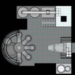
CraneRoom04.jpg

as well as at least one very basic 3d view to give a sense of scale and placement:
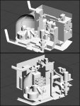
CraneRoom01.jpg

I hear what you're saying about the structure exteriors. A possible solution may be for the description of A1 on L02 to include the above top-down shot and include all those rooftops (L08 D1 etc.) as part of the description? Definitely there will be an initial description of the room as a whole including the intended Robotics room encounter as well as a list of entrances (including broken windows).

As I said, I then intend to break it down into structures. So after describing the whole room (A) I would go through all the levels of Tower B. Inset maps for each keyed listing would just be from that structure. And then Tower C etc. etc. I know the above map makes it look like I'm going level by level for several different structures all at once, but that is not the intent, just what I would put in the map book.

if we look at structures D a, b & c on level 5, they aren't connected to any structure on level 5
yeah, this has been a stumbling block for me. I've been shading sloped floors and I missed these. Basically they are sloped passages radiating down from L07 D1 to the five rooms (D6a-e) on L05. I guess technically those rooms on L05 could be on the L07 map, but that sets a weird precedent for all the other multi-level, sloped passages in the dungeon. I haven't been able to think of another way to denote a slope that doesn't clutter up the map...
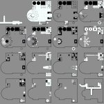
As an example, this shows a couple of multi-level sloped corridors. It also shows how I intend to show things in X-Ray view (which the above 4x4 presentation fails to do) so that everything that lies below the current level can also be seen with darker shading:

1664013075435.png
The lines blocking the tunnels are a by-product of the cross-sectioning of three dimensional object when I initially rendered it. I was going to go back through and get rid of those ceiling lines that appear to be walls across the corridors. Now that you point it out and I really think about it, I guess if I really really hate myself, I could go back through and draw the entirety of a sloping passage on the lowest level on which it originates. I'm reviewing the map right now and it doesn't look like any of them are interrupted mid-slope by rooms or branches. I definitely need to move on from masturbating this art file interminably, but if it's worth doing, I need to know about it now rather than later!

But if this is for publication, or an experiment in creating something for publication
At the very least, I'm pretending like it's for eventual publication. It is definitely an exercise in user interface for me.

I think labelling on the map the connections, between levels or between structures
100% agree. I'm trying to figure out how to do this without crapping up the map with information. My biggest concern is almost all of the stairways exist in stairwells and go up as well as down (ex. L02-16 C9). I shaded them to show the slope, but there's no way to tell if these stairs go down as well as up without flipping to the map of the lower level. Drawing little arrows all over the map will clutter it up. (It would be horribly laborious, but I'm starting to think that instead of presenting the stairs as starting on the level, going up to a landing and bending around to the next level, I should be showing them going half way down to the lower level and up to the landing, half way to the next level?) The alternative is describing each stairway in the dungeon key.

I am a dinosaur.
Yes, you are :p (loudly, proudly), but that doesn't alter the validity of what you keep saying; and I am hearing you (I think?). Like I said, after the initial mega-room (L02 A1) description including all pertinent information to running the giant room as a whole, I would go structure by structure, level by level. Each level description would include an inset map in the body of the dungeon key text of just that level of that structure since characters investigating a building will likely be sticking to that one building for a while.
 

Beoric

8, 8, I forget what is for
Some of these structures have many many levels to them though! But maybe I'm misunderstanding? I wanted to discuss labeling, so I didn't include all the maps that would be used to describe one of these mega-areas. Per Squeen's earlier comments, I would be including a top-down view of the structures in the room sans interior mapping (but with labeling), shaded to convey height:

View attachment 1295

as well as at least one very basic 3d view to give a sense of scale and placement:

View attachment 1296
Yeah, that helps a lot.

yeah, this has been a stumbling block for me. I've been shading sloped floors and I missed these. Basically they are sloped passages radiating down from L07 D1 to the five rooms (D6a-e) on L05. I guess technically those rooms on L05 could be on the L07 map, but that sets a weird precedent for all the other multi-level, sloped passages in the dungeon. I haven't been able to think of another way to denote a slope that doesn't clutter up the map...
I run into this a lot because I have a lot of level changes in my dungeons. As you suggested, my solution is to keep elevation changes on the same map level, so they are not true cross sections. Otherwise I am moving back and forth between maps too often, sometimes for relatively short distances; this is particularly a pain when working with VTTs because you have to move tokens between maps frequently. A lot of my mapping compromises are made so they work better on VTTs.

The only exception to this is when it passes under a structure that is also on the same level. While you do have those in this example, it looks to me like they are not actually connected to other structures on that level, so the whole structure can be moved up a couple of map levels (the level 5 structures become level 7, and the level 6 structures become level 8, etc.), with a notation on the map or in the key that they are -20' (or whatever).

As an example, this shows a couple of multi-level sloped corridors. It also shows how I intend to show things in X-Ray view (which the above 4x4 presentation fails to do) so that everything that lies below the current level can also be seen with darker shading:
I use shading the same way.


When I can't keep a continuous flow on the map, I sometimes indicate connections on the map (so connection "A" on level 5 matches connection "A" on level 7). At the very least I think you need a notation to indicate that the exit is not a wall, but is a continuation of a corridor - a zigzaggy "break" line works, if you understand what I am referring to.

I think you also need a very clear notation in the key in every case. It is immensely frustrating when you have an exit from a level and can't figure out where the hell it goes.

100% agree. I'm trying to figure out how to do this without crapping up the map with information. My biggest concern is almost all of the stairways exist in stairwells and go up as well as down (ex. L02-16 C9). I shaded them to show the slope, but there's no way to tell if these stairs go down as well as up without flipping to the map of the lower level. Drawing little arrows all over the map will clutter it up. (It would be horribly laborious, but I'm starting to think that instead of presenting the stairs as starting on the level, going up to a landing and bending around to the next level, I should be showing them going half way down to the lower level and up to the landing, half way to the next level?) The alternative is describing each stairway in the dungeon key.
Sometimes the thing in your head is just too complicated to effectively communicate, and you have to simplify it if somebody else is going to consume it. So if you can't come up with a notation that communicates it, then change the configuration of the stairs to something you can communicate. It's like editing any other writing; sometimes you have to give up some bits you love to make the whole thing work.
 
Top